


GPS Logger

Description of GPS Logger
BasicAirData GPS Logger হল আপনার অবস্থান এবং আপনার পথ রেকর্ড করার জন্য একটি সহজ অ্যাপ।
এটি একটি মৌলিক এবং হালকা ওজনের জিপিএস ট্র্যাকার যা শক্তি সাশ্রয়ের দিকে নজর দিয়ে নির্ভুলতার উপর দৃষ্টি নিবদ্ধ করে।
এটি অফলাইনে কাজ করে (ইন্টারনেট সংযোগ ছাড়া), এতে কোনো সমন্বিত মানচিত্র নেই।
আপনি যদি সেটিংসে EGM96 উচ্চতা সংশোধন সক্ষম করেন তবে এই অ্যাপটি অর্থোমেট্রিক উচ্চতা (সমুদ্র পৃষ্ঠের উপরে উচ্চতা) নির্ধারণে খুব সঠিক।
আপনি আপনার সমস্ত ভ্রমণ রেকর্ড করতে পারেন, সরাসরি অ্যাপ-মধ্যস্থ ট্র্যাকলিস্ট থেকে যেকোনও ইনস্টল করা বহিরাগত দর্শকের সাথে সেগুলি দেখতে পারেন এবং সেগুলিকে KML, GPX, এবং TXT ফর্ম্যাটে বিভিন্ন উপায়ে ভাগ করতে পারেন৷
অ্যাপটি 100% ফ্রি এবং ওপেন সোর্স।
শুরু করার নির্দেশিকা:
https://www.basicairdata.eu/projects/android/android-gps-logger/getting-started-guide-for-gps-logger/
ইহাতে অতিরিক্ত বৈশিষ্ট্যগুলিও উপস্থিত রয়েছে:
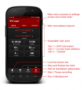
- একটি আধুনিক UI, একটি কম খরচের গাঢ় থিম এবং একটি ট্যাবযুক্ত ইন্টারফেস সহ
- অফলাইন রেকর্ডিং (অ্যাপটিতে কোনো সমন্বিত মানচিত্র নেই)
- ফোরগ্রাউন্ড এবং ব্যাকগ্রাউন্ড রেকর্ডিং (অ্যান্ড্রয়েড 6+ এ অনুগ্রহ করে এই অ্যাপের জন্য সমস্ত ব্যাটারি পর্যবেক্ষণ এবং অপ্টিমাইজেশন বন্ধ করুন)
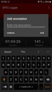
- রেকর্ডিং এর মধ্যেও টীকা তৈরি করা
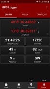
- জিপিএস তথ্যের ভিজ্যুয়ালাইজেশন
- ম্যানুয়াল উচ্চতা সংশোধন (একটি সামগ্রিক অফসেট যোগ করা)
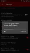
- স্বয়ংক্রিয় উচ্চতা সংশোধন, NGA EGM96 আর্থ জিওয়েড মডেলের উপর ভিত্তি করে (আপনি সেটিংসে এটি সক্ষম করতে পারেন)। আপনার ডিভাইসে ইন্টারনেট অ্যাক্সেস না থাকলে, আপনি এই সাধারণ টিউটোরিয়ালটি অনুসরণ করে ম্যানুয়ালি এই বৈশিষ্ট্যটি সক্ষম করতে পারেন: https://www.basicairdata.eu/projects/android/android-gps-logger/application-note-gpslogger/manual- প্রাথমিক-এয়ার-ডেটা-জিপিএস-লগারের জন্য-ইজিএম-উচ্চতা-সংশোধন-এর সেটআপ
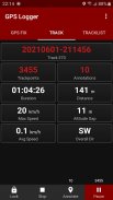
- রিয়েল টাইম ট্র্যাক পরিসংখ্যান
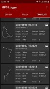
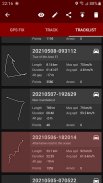
- ইন-অ্যাপ ট্র্যাকলিস্ট রেকর্ড করা ট্র্যাকের তালিকা দেখাচ্ছে
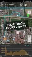
- সরাসরি ট্র্যাকলিস্ট থেকে ইনস্টল করা KML/GPX ভিউয়ার ব্যবহার করে আপনার ট্র্যাকের ভিজ্যুয়ালাইজেশন
- KML, GPX, এবং TXT-এ রপ্তানি ট্র্যাক করুন
- ট্র্যাক শেয়ারিং, KML, GPX, এবং TXT ফরম্যাটে, ই-মেইল, ড্রপবক্স, গুগল ড্রাইভ, FTP, ... এর মাধ্যমে
- মেট্রিক, ইম্পেরিয়াল বা নটিক্যাল ইউনিট ব্যবহার করে
এটি ব্যবহার করুন:
☆ আপনার ট্রিপ ট্র্যাক রাখুন
☆ সঠিক স্ট্যাটিক এবং গতিশীল পরিমাপ করুন
☆ আপনার স্থানচিহ্ন যোগ করুন
☆ আপনার দেখা সেরা জায়গাগুলি মনে রাখবেন
☆ আপনার ছবি জিও ট্যাগ করুন
☆ আপনার বন্ধুদের সাথে আপনার ট্র্যাক শেয়ার করুন
☆ OpenStreetMap মানচিত্র সম্পাদনায় সহযোগিতা করুন
ভাষা:
এই অ্যাপটির অনুবাদ ব্যবহারকারীদের অবদানের উপর ভিত্তি করে। প্রত্যেকেই ক্রাউডিন (https://crowdin.com/project/gpslogger) ব্যবহার করে অনুবাদে অবাধে সাহায্য করতে পারে।
F.A.Q:
কোনো সমস্যার ক্ষেত্রে, আপনি প্রায়শই জিজ্ঞাসিত প্রশ্নগুলি পড়তে সাহায্য করতে পারেন (https://github.com/BasicAirData/GPSLogger/blob/master/readme.md#frequently-asked-questions)।
গুরুত্বপূর্ণ নোট:
যখন অ্যাপটি ফোরগ্রাউন্ডে থাকে তখন জিপিএস লগারে অবস্থানটি সর্বদা অ্যাক্সেস করা হয় (শুরু করা হয়) এবং তারপর পটভূমিতেও সক্রিয় রাখা হয়। অ্যান্ড্রয়েড 10+ এ অ্যাপটির "কেবল অ্যাপ ব্যবহার করার সময়" লোকেশনের অনুমতি প্রয়োজন। এটির "সব সময়" অনুমতির প্রয়োজন নেই।
আপনার অ্যান্ড্রয়েড সংস্করণের উপর নির্ভর করে, আপনি যদি পটভূমিতে নির্ভরযোগ্যভাবে GPS লগার চালাতে চান, তাহলে আপনাকে সমস্ত ব্যাটারি অপ্টিমাইজেশন অক্ষম করতে হবে। উদাহরণস্বরূপ, আপনি Android সেটিংস, অ্যাপস, GPS লগার, ব্যাটারিতে যাচাই করতে পারেন যে ব্যাকগ্রাউন্ড অ্যাক্টিভিটি অনুমোদিত এবং ব্যাটারি ব্যবহার অপ্টিমাইজ করা হয়নি।
অতিরিক্ত তথ্য:
- কপিরাইট © 2016-2022 BasicAirData - https://www.basicairdata.eu
- অতিরিক্ত তথ্যের জন্য দয়া করে দেখুন https://www.basicairdata.eu/projects/android/android-gps-logger/
- এই প্রোগ্রামটি বিনামূল্যের সফ্টওয়্যার: আপনি এটিকে পুনরায় বিতরণ করতে পারেন এবং/অথবা ফ্রি সফ্টওয়্যার ফাউন্ডেশন দ্বারা প্রকাশিত GNU জেনারেল পাবলিক লাইসেন্সের শর্তাবলী অনুসারে, লাইসেন্সের সংস্করণ 3 বা (আপনার বিকল্পে) পরবর্তী সংস্করণে। আরও বিস্তারিত জানার জন্য GNU জেনারেল পাবলিক লাইসেন্স দেখুন: https://www.gnu.org/licenses।
- আপনি গিটহাবে এই অ্যাপটির সোর্স কোড দেখতে এবং ডাউনলোড করতে পারেন: https://github.com/BasicAirData/GPSLogger
- যখন EGM96 স্বয়ংক্রিয় সংশোধন প্রথমবার সেটিং স্ক্রিনে সক্রিয় করা হয়, তখন জিওয়েড উচ্চতার ফাইলটি OSGeo.org ওয়েবসাইট থেকে ডাউনলোড করা হয়। (ফাইলের আকার: 2 এমবি)। একবার ডাউনলোড হয়ে গেলে, এটি ব্যবহার করার জন্য আর কোন ইন্টারনেট সংযোগের প্রয়োজন নেই।
GPS Logger - Version 3.2.3
(11-12-2024)
GPS Logger - APK Information
APK Version: 3.2.3Package: eu.basicairdata.graziano.gpsloggerLatest Version of GPS Logger
Other versions


Apps in the same category

You may also like...


